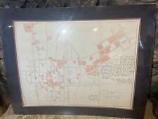
1893 Map of the lower part of the city of Honolulu and the harbor front orginal

When you click on links to various merchants on this site and make a purchase, this can result in this site earning a commission. Affiliate programs and affiliations include, but are not limited to, the eBay Partner Network.

1893 Map of the lower part of the city of Honolulu and the harbor front orginal:
$4500.00
1893 Map of the lower part of the city of Honolulu and the harbor front orginal.
This is a rare and valuable original antique print.
Description: This early map of “Part of the City of Honolulu, Oahu, H.I.” Was surveyed by F.S. Dodge in 1992. W.D. Alexander has written a statement stating that “the areas colored red were, to the best of my knowledge and belief, owned or leased by Americans on the 17th day of January 1893” scale is 200 feet equals 1 inch. This map was produced in the last decade of the monarchy, as W.D. Alexander was Surveyor General to Queen Liliuokalani prior to her overthrow.
Size: 26 1/2 x 35
Date: 1893
Publisher/Printer U.S. Government Printing Office
1893 Map of the lower part of the city of Honolulu and the harbor front orginal:
$4500.00
Related Items:
1893 Map of the lower part of the city of Honolulu and the harbor front orginal
$4500.00

Antique Map of California Very Early Winemaking 1893 HS Crocker Geographical Map
$676.50

Railroad Train Manual Locomotive Map Lithograph Color Rail Line Prints POOR'S US
$649.83